DeepRoad automates the analysis of videos obtained in road condition surveys. There are two individual modules within DeepRoad. One module automatically detects and characterises/classifies pavement distresses such as cracks, potholes, ravelling, and patching. The second module detects and geo-locates linear transportation assets like lampposts, traffic signs, marker posts, etc. Depending on their needs, the end users can pay and access a specific analysis service module.
DeepRoad is offered to a market that has very high per kilometre surface inspection costs. Equally, Right-of-way (ROW) videos go largely unanalysed due to high labour costs. DeepRoad, Strada Imaging’s software-as-a-service (SaaS) offering, decouples video capture from analysis, allowing the customers the flexibility of performing inspection with their own camera systems and personnel whenever they want. The customers can selectively analyse data within DeepRoad. Hence, they are in complete control of what they want to analyse and when. In marked contrast to the other automated analysis solutions for pavement surface analysis on the market, DeepRoad interfaces are set up to provide the customer with intermediate outcomes of its analysis as well as the conclusions. This level of transparency is required to build confidence in the automation. A big advantage of DeepRoad is its ability to measure dimensions of distresses in 3D.
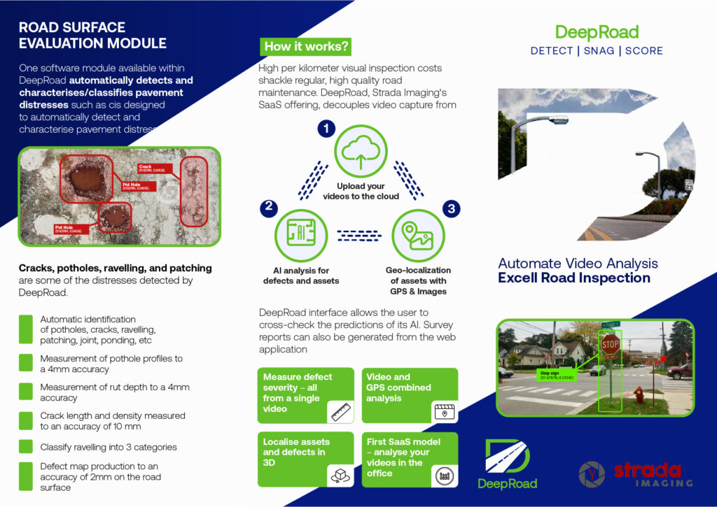
A serious deficiency in most visual road inspection software offerings in the market, except TRACS and SCANNER, is that they cannot measure distress dimensions. For instance, key parameters such as rutting depth and cracking area that determine the condition of the pavement can only be measured with laser scanners. Laser scanners require high capital expenditure and therefore are continually being replaced by other cheaper technologies. DeepRoad’s industry-leading AI solution entirely removes the need for laser scanners, measuring critical distress parameters directly from video footage from either one or multiple cameras. Linear assets are inventoried and mapped in 3D with their GPS localization. DeepRoad can also automatically recognise more than 580 traffic sign types used in the UK.
The biggest challenge that Strada Imaging tackled in developing DeepRoad is training a robust AI that can analyse videos obtained from different camera systems. The solution is the result of years of multi-disciplinary R&D, within Strada Imaging and its academic collaborators, spanning 3D imaging, AI, and software engineering.
Key features
The pavement surface module of DeepRoad boasts of the following (subject to a high-quality video input):
1. Automatic identification of potholes, cracks, ravelling, patching, joints, ponding, etc
2. Measurement of pothole profiles to a 4mm accuracy in 3D (perimeter, area, depth, etc.)
3. Measurement of rut depth to a 4mm accuracy
4. Cracking length and density measured to an accuracy of 10 mm
5. Classifies ravelling into 3 categories
6. Overlaying/superimposing of defect map on the local road surface, locating defects with 2 mm accuracy
The linear assets service module of DeepRoad:
1. Identifies lamp posts, traffic signs, marker posts, bus stops, and gully covers
2. Identifies 580 UK traffic sign types individually
3. Locates assets to a resolution better than that of GPS
4. Maps parked cars, enabling resurveys in those areas
5. Traffic cone identification and GPS-style localization
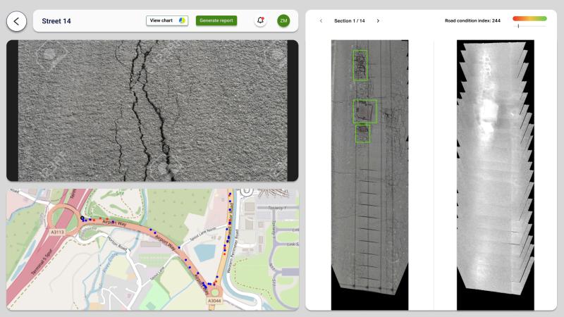
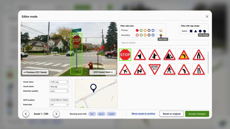
DeepRoad dashboard consists of multiple displays, showing different analysis outcomes including annotated image streams, and Google maps embedded with detections. The dashboard also consists of an interface, using which the users can review and modify the decisions of the AI. Users pay per kilometre of video data analysed. DeepRoad has a 24-hour all-year-around availability. The software makes use of Google Cloud ensuring 100% uptime.