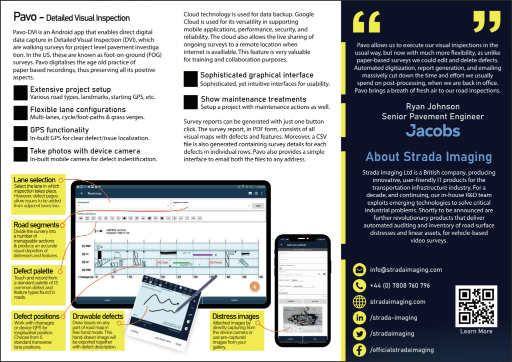
Pavo is a mobile application designed to support visual condition surveys of road networks. It provides structured workflows for both Coarse Visual Inspection (CVI) and Detailed Visual Inspection (DVI), enabling surveyors to assess carriageway and footway condition in a consistent and repeatable manner. The app replaces paper forms, standalone cameras, and manual data entry with a single, integrated digital process.
Pavo is intended for use in highway maintenance teams, local authority road inspection units, consulting engineers, and survey contractors. It can be used in driven surveys (CVI) to record overall network condition, or walked inspections (DVI) where individual defects are captured with precise location and photographic evidence.
The app is designed to operate offline, allowing surveys to continue uninterrupted in remote areas or when cellular coverage is poor. Once connectivity becomes available, survey data can be synchronised and exported for reporting and asset management workflows.
Inspection Workflows
1. Coarse Visual Inspection (CVI)
- Used for network-level assessments where broad condition indicators are collected across long road sections.
- Records condition of carriageway and footway sections.
- Uses predefined defect and condition categories.
- Suitable for vehicle-based or rapid walk-through surveys.
- Produces consistent condition grading useful for maintenance planning.
2. Detailed Visual Inspection (DVI)
- Used for targeted site inspections and follow-up investigations.
- Records individual defects with dimensions, photographs, severity, and location.
- Captures supporting notes and annotations for decision-making.
- Suitable for footway inspections, high-priority sections, and known problem areas.
- Creates precise records required for repairs, claims response, and audit evidence.
Features
- Integrated CVI and DVI survey modes: Enables teams to use a single tool for both broad network surveys and detailed follow-up assessments.
- GPS location tagging: Each recorded defect or section entry is associated with geographic coordinates to support traceability.
- Photo capture and annotation: Inspectors can attach photographs and add clarifying notes to support repair justification.
- Structured defect and condition terminology: Ensures all inspectors use consistent categories and severity grading.
- Offline field operation: Surveys can be completed without connectivity; data sync happens when the device is back online.
- Export for asset management and reporting: Survey results can be exported for integration with maintenance planning systems or GIS platforms.
- Tablet and smartphone compatibility: Runs on standard Android devices, avoiding reliance on specialised hardware.
- Clear inspection workflows: Supports repeatable, procedure-aligned inspection tasks across different teams.
Benefits
- Reduces dependency on manual recording and transcription.
- Improves consistency between different inspectors and survey teams.
- Provides verifiable records for maintenance planning and audit enquiries.
- Accelerates field-to-report turnaround time.
- Supports strategic prioritisation of resurfacing and patching programs.
Suitable For
- Highway Authorities and Road Asset Owners
- Maintenance and Network Management Contractors
- Civil Engineering & Transport Consultancy Firms
- In-house Road Inspection and Audit Teams
If you would like to learn more about how Pavo can support your inspection workflow, our team can provide a walkthrough and answer technical or operational questions.
Email: [email protected]